Balaghat Tourism Madhya Pradesh India
Search for Hotels in Madhya Pradesh
General Info of Balaghat
History of Balaghat
In 1845 AD the “Gondwana Kingdom” included in British rule the then Capital Kolkata of India by the action of Lord Dalhousie on abolition of “Practice of Adoption” and was named as “Baraghat” against the name proposed “Barahaghat” and officially spoken as “Balaghat” spelt ‘l’ as ‘r’. The hilly areas mostly known as Kanjaighat, Saletekrighat, Baisanghat, Dongrighat, Ramramaghat, Teepagharghat, Kavharghat, Dongriyaghat were covered under this region. “Balaghat” district was formed along with some parts of the Central Provinces of Bhandara, Seoni, and Mandla Districts as was part of Central Province of Nagpur which was Capital for British with two tahsils “Balaghat” and “Baihar”.
The name “Balaghat” was originated because of the more hilly regions in this district. The regions of “Balaghat” district were the concern of Maratha rulers before British. The word “Bala” means “Best” in Marathi Language. The name “Balaghat” was called because the people are “Best People” (Balao) as “Balao ka ghat”
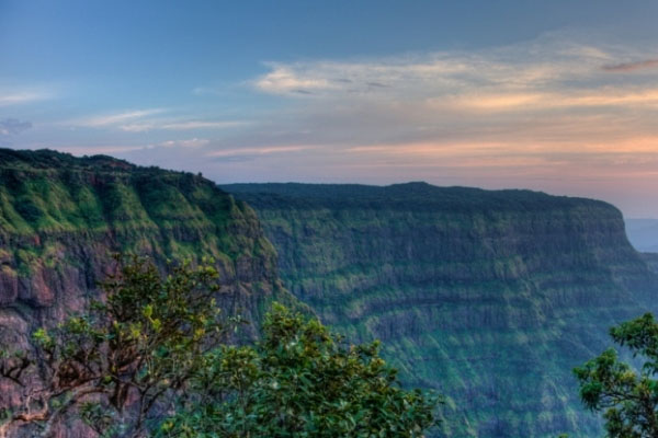
Balaghat District is located in the southern part of Jabalpur Division. It occupies the south eastern portion of the Satpura Range and the upper valley of the Wainganga River. The total area of the district is 9,245 km². Balaghat District is bounded by Mandla District of Madhya Pradesh to the north, Dindori District to the northwest, Rajnandgaon District of Chhattisgarh state to the east, Gondia and Bhandara districts of Maharashtra state to the south, and Seoni District of Madhya Pradesh to the west. The Main language spoken in district is Hindi, Gondi in Baihar & Ukwa, Lodhi in paraswada, Northern parts of Balaghat tehsil and Bharveli, Kalari in Lanji & kirnapur, Pawari in western parts i.e. Waraseoni, Katangi & Lalbarra and Marathi in the southern part of district.
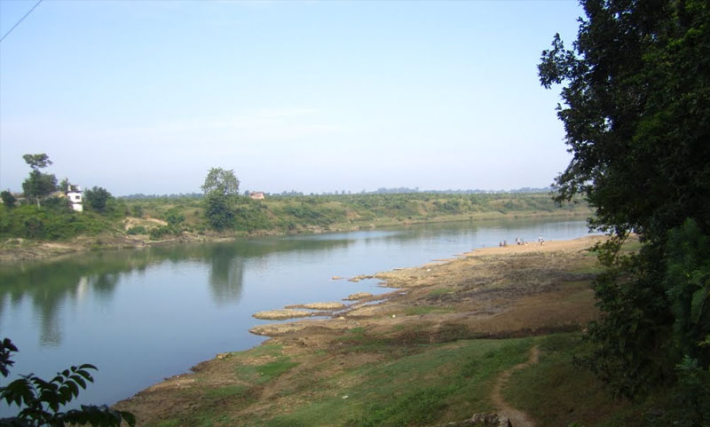
The Wainganga and its tributaries are the most important rivers in the district. The town of Balaghat is situated on the Bank of River Wainganga, which flows north to south through the district and Enters in Balaghat District by Merging with Thanwar river near Nainpur of Mandla District. The Bagh, Nahra and Uskal rivers are tributaries of the Wainganga. The Bawanthadi and Bagh rivers define the boundary with Maharashtra.
The southern part of the Vindhyan Range up to Katangi is called Lower Bhander Range. Beyond this point the escarpment enclosing the land-locked valley of Sirampur and the hill range in continuation is called the Kaimur Range.
Geographically the district is divided into three distinct parts:
The southern lowlands, a slightly undulating plain, comparatively well cultivated and drained by the Wainganga, Bagh, Deo, Ghisri and Son rivers.
The long narrow valley known as the Mau Taluka, lying between the hills and the Wainganga river, and comprising a long, narrow, irregular-shaped lowland tract, intersected by hill ranges and peaks covered with dense jungle, and running generally from north to south.
The lofty plateau, in which is situated the Raigarh Bichhia tract, comprising irregular ranges of hills, broken into numerous valleys, and generally running from east to west. The highest points in the hills of the district are as follows: - Peaks above Lanji, 2300 or 2,500 feet (760 m); Tepagarh hill, about 2,600 ft (790 m).; and Bhainsaghat range, about 3,000 ft (910 m) above the sea. The Banjar, Halon and Jamunia rivers, tributaries of the Narmada, drain a portion of the upper plateau.
Economy
About 80% of the manganese production in India comes from Balaghat District. The recently discovered copper deposit at Malanjkhand is regarded as the largest in the country. Bauxite, Kyanite, Marble, Dolomite, Clay and limestone are the other main minerals of the district.
In 2006 the Ministry of Panchayati Raj named Balaghat one of the country's 250 most backward districts (out of a total of 640).[5] It is one of the 24 districts in Madhya Pradesh currently receiving funds from the Backward Regions Grant Fund Programme (BRGF).
Photo Gallery of Balaghat


How to get there
By Air
There are no regular flights from other major cities of the country to Balaghat. Nearest airport is Jabalpur Airport.
Balaghat is 145 km away from Jabalpur Airport (JLR), Jabalpur, Madhya Pradesh
Balaghat is 132 km away from Sonegaon Airport (NAG), Nagpur, Maharashtra
By Rail
Balaghat is found over the broad gauge line of Jabalpur-Balaghat, and Balaghat-Gondia of South-Eastern Railway. Railway Stations: Balaghat Junction (BTC), Charegaon (CRN)
By Road
Balaghat is extremely connected by road, where the State Highways 11 and 26 are found to be the nearest highways to the Balaghat. You can easily get regular buses and taxis to Balaghat from other major cities of the country.